Scientific activity


-
Study of Landslides and Mudflow Processes in Kyrgyzstan
In recent years, the goals of studying landslides have been achieved, and work continues on further research using geological, geophysical methods, and Earth Remote Sensing (ERS) data.
Using ERS methods and data in conjunction with field surveys, employees have conducted an inventory of landslide-prone areas and updated the catalog for the southern part of Kyrgyzstan from 2013 to 2018. The catalog included 649 landslide-prone areas that pose threats to residential buildings, socially significant objects, engineering infrastructure, roads, and agricultural lands. It was determined that 317 of these areas are located in the densely populated Osh region, which has a population of 1.1 million people. The results of these works were transmitted to the Ministry of Emergency Situations of Kyrgyz Republic.
In 2022, the Asian Development Bank (ADB) allocated a grant of over $30 million to Kyrgyzstan for both structural and non-structural measures aimed at reducing landslide disaster risks.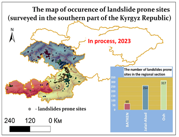
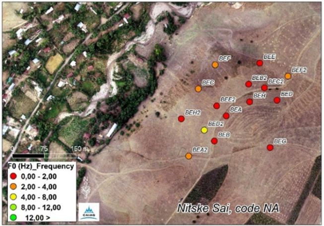
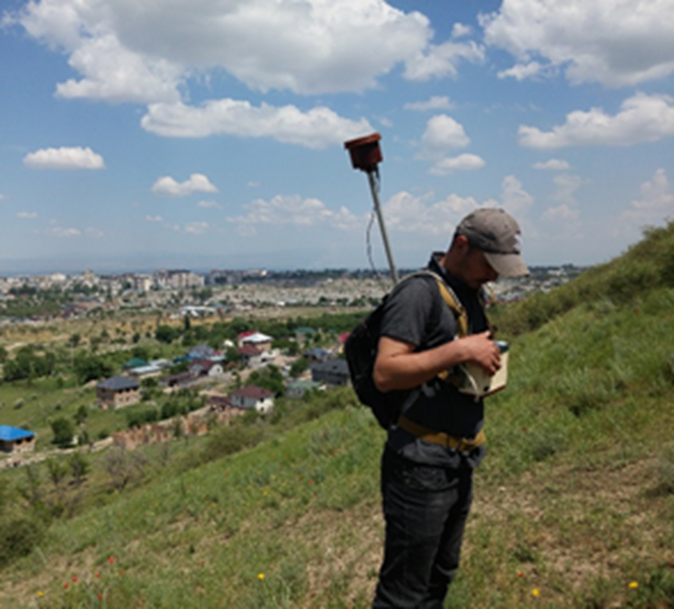
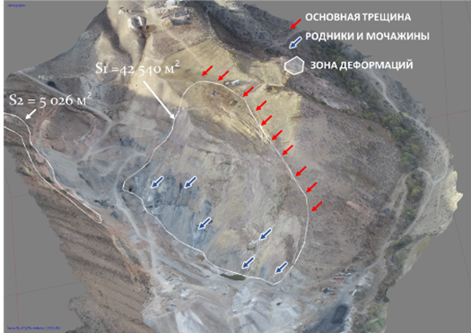
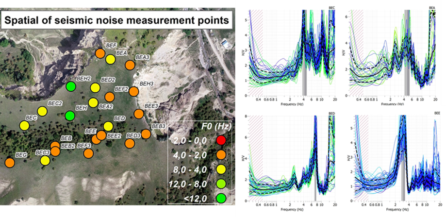
According to the materials of the department "Geodynamics and Georisk", CAIAG A map with the location of the seismic noise measurement points on the Beske Sai site, according to the research materials "Geodynamics and Georisk", CAIAG, was carried out as part of the Abr project
Study of Mudflow Hotspots
This is a new research topic approved by the Consultative Council for the upcoming years. The aim is to identify causal relationships in the formation and activation of mudflows and to establish a sustainable research system for studying this phenomenon.
Mudflows and floods are the main recorded types of hazardous natural processes in Kyrgyzstan, accounting for a cumulative share of 30% of all hazardous processes. Over the past 20 years, there has been a 1.12-fold increase in their registration, exceeding the average value. The destruction of existing mudflow protection structures and the formation of new hotspots lead to mudflow and flood damage, affecting populated areas (95% of all settlements in the country are located on the banks or alluvial cones of rivers or temporary watercourses), agricultural lands, pastures, transportation networks, as well as hydraulic and irrigation systems.
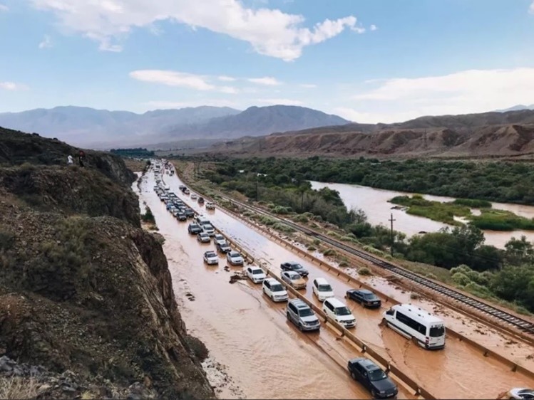
Consequences of the mudflow July 30, 2022 Boom Gorge, *Internet source
-
Study of contemporary tectonic movements in the fault zones of the Pamir-Tian Shan junction
. The geodynamic processes occurring at the junction of the Pamir and Tian Shan mountain ranges (in the Pamir-Tian Shan junction zone), particularly the contemporary tectonic movements and associated seismic events, have always been of great interest to scientists. The contemporary tectonic movements, stress state of the mountain ranges, fault activity, and their connection to seismic events in the Pamir-Tian Shan junction zone have been insufficiently studied.
The local community residing in the high mountain zone is highly vulnerable to seismic events, and according to the catalog of earthquakes by CAIIZ, 30 events with a magnitude greater than 5.0 have been recorded during the period of 2010-2022.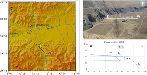
West Alai GPS network. Offsets relative to the fourth ALA1 (left). View of the segment of the Aram-Kungei fault with morphometric parameters (right). On the map, the location of this segment of the fault is indicated by the letter F.
The GPS observations conducted by CAIIZ in this area have revealed significant displacements of 6 mm/year along the West Alai profile, where 7 stations are installed. Particularly significant deformations occur in the junction zone, where the Aram-Kungey strike-slip fault passes [Zubovich et al., 2016].
The Saraz earthquake with a magnitude of Mw7.2 that occurred in the Pamir region in 2015, followed by the Sary-Tash earthquake with a magnitude of Mw6.4 in 2016, interrupted the moderate course of tectonic movements, altered the tectonic regime, and consequently provided new insights into the impact of seismic events on the Earth's crust.
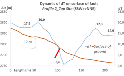
Preliminary results from our research indicate that in the area of the Zaalai Foothills and Alai Valley, at least two fault systems can be clearly distinguished: the Aram-Kungey fault with right-lateral strike-slip motion, crossing the Altyn-Dara river valley, and the main thrust in the Zaalai Range zone. These faults are well expressed in the topography, forming scarps and terraces, and occasionally exhibiting suffosional sinkholes and subsidence surfaces.
Paleoseismological analysis estimating the magnitude of the seismic event that formed the scarps yielded an average cumulative value of Msr = 7.6 (according to Nikonov A.A., 1983). Considering other contemporary and historical seismic events that have occurred in this region, it confirms its significant tectonic activity.
For studying fault zones, a comprehensive approach utilizing instrumental measurements (GPS, drones, geophysical equipment), remote sensing methods, and GIS technologies remains relevant. Investigating modern tectonic movements using geological, geophysical, and geodetic methods will contribute to and expand our understanding of the fault zone's structure, types of displacements and their amplitudes, the main slip zone (fault plane), rock structure, as well as its current activity. -
Seismology and seismic hazard assessment
The entire territory of Kyrgyzstan is located in a highly seismic zone and is exposed to seismic hazards and risks. Earthquakes pose a high danger to densely populated areas and major cities in Kyrgyzstan.
In this regard, the study of seismic effects on buildings and engineering structures during significant earthquakes becomes particularly relevant. The relevance is also driven by the use of new technologies and methods, specifically:
a) Measurements of Vs30, which allow for the creation of "Maps typifying the distribution of Vs30 velocity at a depth of 30 meters for any site;
b) Creation of high-resolution digital elevation models (DEMs) (1 arc-second ~ 30 meters) to adapt Vs30 to specific terrains.
These methods are also applicable for studying landslides, landslide-prone slopes, and tectonic fault zones.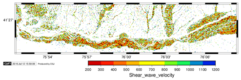
Map of shear wave velocity distribution using the slope as a proxy, built by the Vs30 method for the city of Naryn and its agglomeration.
The main objective of these studies is to investigate the use of Vs30 in refining the assessment of seismic events' impact on densely populated areas and major cities. To achieve this goal, it is necessary to consistently determine the site parameters in urban areas that will help explain variations in its amplification.
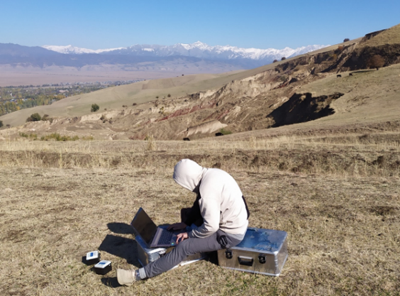
The stated research objectives determine our methodological topics, and instrumental measurements and observations are applied to address practical tasks, such as passive and active seismology, electrical resistivity tomography for electrical reconnaissance, magnetometry, and H/V analysis of site data.
-
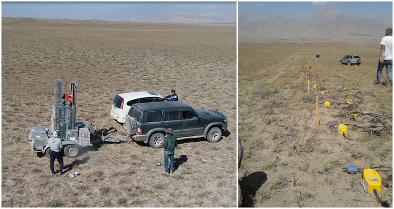
Seismic rig measurements along the long Komansuu profile together with colleagues Section 2.2,
GFZ (Germany) (left and middle). Preparing for measurements with Data Cube seismic recorders on a landslide (right).
Magnetometric measurements in the fault zone. The graph illustrates the dynamics of changes in the magnetic field on the Aram-Kungsei fault (Western segment)
-
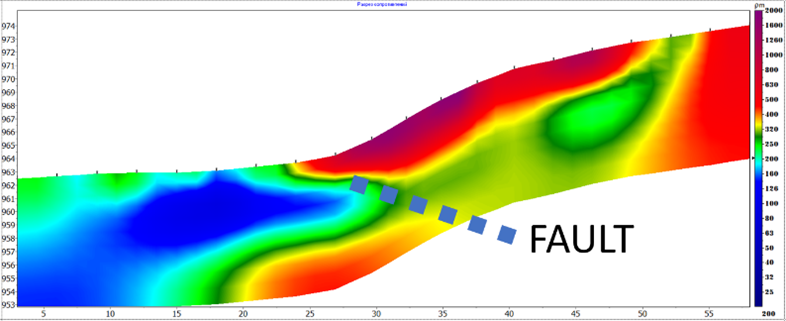
Electroresistive tomography (VES, EP, etc.) in the zone of faults and fluids. The picture illustrates a geoelectric section (Electrotomography, ERT) in the Pamir-Alai thrust zone, Achy-Suu segment.
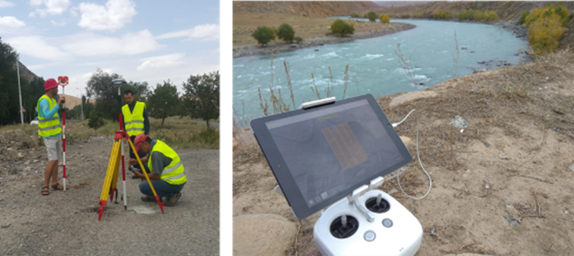
Geodetic and aerial photogrammetric measurements of the terrain
Terrain assessment using the Nakamura method (Site effect)