Department 3 "Monitoring Systems and Data Management"
Head of the Department: Dr. A. Zubovich
The main activities of the department are as follows:
The development of the Green Legacy web platform has been completed
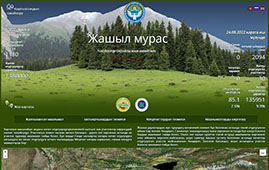
Development of the web platform "Jashyl muralas" was completed in order to implement the Roadmap for the Year of Mountain Ecosystems Protection and Climate Resilience, approved by the Order of the Cabinet of Ministers of the Kyrgyz Republic on March 1, 2022 № 95-p,
The purpose of the platform "Jashyl muras" is to create a special portal, which will provide information about the forest areas of Kyrgyzstan and the needs for planting seedlings in them, so that interested individuals and legal entities can provide assistance in the form of financial assistance to increase the forested areas of Kyrgyzstan. This will allow for targeted restoration work and make a significant contribution to increasing the forests of Kyrgyzstan.
Подробнее...
Performance of works under the GIS Vodokanal project
Within the framework of the project "Creation of a geographic information system of the Karakol city with the support of an information Internet portal," from 12 to 17 February, 2024, the department employees traveled to the Karakol city. The purpose of the trip was to meet with representatives and employees of the Karakol communal enterprise Vodokanal to resolve issues related to the implementation of the GIS Vodokanal system, determine the coordinate points of wells for mapping them, as well as verify the correctness of applying the water supply system and linking the subscriber base to the sites.
Works at stations under GCO project
 In February 2024, the department employees carried out a planned trip to repair automatic stations in the Naryn and Issyk-Kul regions. At all stations was maintenanced, cleaning of sensors from dust, dirt and repair work were carried out. In particular, the battery at the KEKI station was changed, the water temperature sensor at the ZOKA station was replaced, the power supply at the KRGT station was corrected and malfunctions in the LAGU station were eliminated.
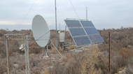
Scheduled technical inspection of JERU station
In early March 2024, according to the agreement with Alliance Altyn LLC for the maintenance and production of statistical calculations of meteorological parameters, the department employees made a planned trip to the Jerui mine to carry out these works. Maintenance was carried  out, cleaning the sensors from dust and dirt and checking the operability of the station. At the end of the work, a report was written and sent to the company's management.
The department has 13 employees divided into 3 sections
The Monitoring Systems Section installs new and maintains existing stations aimed at seismological, hydrometeorological and GNSS observations in Kyrgyzstan, Kazakhstan, Uzbekistan, Tajikistan and Afghanistan. All stations are unattended, self-contained and automatic.
Seismic monitoring is carried out at the expense of 3 own broadband stations, as well as stations of other networks. All data are transferred via SeisComp3 software system to the central CAIAG server, where they are automatically processed. As a result an operative catalog of earthquakes is created. At present, the network of 18 strong motion stations installed under the ACROSS project and placed in Kyrgyzstan is also operating. The network serves as the basis of the system of early warning from earthquakes.
Hydrometeorological monitoring is performed by 22 automatic stations of CAIAG installed according to CAWa and EBA projects and representing an operational system of collection and primary processing of meteorological and hydrological information. Data from the stations are transmitted to the SDSS database via satellite and GSM communication channels.
CAIAG also carries out GNSS monitoring, continuously developing a network of permanent GNSS stations in Central Asia. Currently, the department maintains 32 permanent GNSS stations. Data are collected automatically via the Internet, satellite and mobile communication.
One of the activities of the Geographic Information Systems section is the creation of such systems using databases and Web-interface. As a result, a number of significant projects have been implemented:
- Sustainable Development of Issyk-Kul. Geographic Information System and Asset Inventory
- Security of Schools and Preschool Educational Organizations in Kyrgyzstan
- Mass digitization of cadastral maps of Chui oblast
- Disaster Risk Data Platform of Kyrgyzstan
- National wildlife database of Kyrgyzstan
- Water Information System
- Geoinformation system Narynvodokanal
- Forest Management Information System
- Jashyl Muras (Green Heritage) web portal
A Sensor Data Storage System (SDSS) has been established as part of the Water in Central Asia project. SDSS is the main repository and access point to meteorological and hydrological data of all CAIAG stations in Central Asia, as well as to other data, including radar altimetry of many Asian, African and South American water bodies.
The purpose of the IT infrastructure section is to develop and maintain the institute's fleet of workstations, peripheral devices, server and communication equipment and their software. Much attention is paid to virtualization systems.
The Department is working on the study of modern movements of the Earth's crust in Central Asia. For this purpose, automatic collection of GNSS data from all CAIAG stations as well as from some IGS stations is organized. Processing of daily data is made by Gamit/Globk programs also in automatic mode. Recently, the department has concentrated a lot of efforts on studying the deformation processes near tectonic faults. The Alay valley of Kyrgyzstan was chosen as a polygon, where one of the most significant relative movements of the earth's surface in Central Asia are observed and where a network of 10 continuously operating GNSS stations is installed.
| Projects |
Years |
Donors |
Beneficiaries |
Foreign partners |
CAIAG |
| Main performers |
Participants |
| MONITORING SYSTEMS (9) |
| CAWa - Water in Central Asia. Work package 1. (Regional hydrometeorological monitoring) |
2008 - 2013 |
German Foreign Ministry |
Hydrometeors of Central Asia |
GFZ |
3 dep. |
|
| ACROSS - Seismic Hazard Early Warning System |
2015 - 2017 |
German Foreign Ministry |
Ministry of Emergency Situations of Kyrgyzstan |
GFZ |
3 dep. |
1 dep. |
| ACROSS - Geodetic Hazard Monitoring Infrastructure |
2014 - 2017 |
German Foreign Ministry |
GFZ |
GFZ |
1 end 3 dep. |
|
| SOSEWIN - Building condition monitoring |
2018 - 2019 |
German Foreign Ministry |
GFZ |
GFZ |
1 end 3 dep. |
|
| LORAWAN |
2022 - 2023 |
ISOC |
ISOC |
ISOC |
1 end 3 dep. |
|
| Kumtor well |
202 - ... |
|
|
|
2 dep. |
3 dep. |
| Jerooy meteo |
с 2022 |
LLC Alliance Altyn |
LLC Alliance Altyn |
LLC Alliance Altyn |
3 dep. |
|
| Ecosystem-Based Climate Change Adaptation in Highlands of Central Asia (EBA) |
1016 - 2018 |
GIZ |
GIZ |
GIZ |
2 dep. |
3 dep. |
| Expansion of a comprehensive seismic monitoring network on the territory of Uzbekistan. |
с 2023 |
Center for Advanced Technologies under the Ministry of Innovative Development of the Republic of Uzbekistan (CAT MID RU) |
CAT MID RU |
CAT MID RU |
1 end 3 dep. |
|
| |
|
|
|
|
|
|
| INFORMATION SYSTEMS (14) |
| Jashyl Muras Web Portal |
2022 |
The World Bank |
Forest Service of the Ministry of Agriculture of the Kyrgyz Republic |
|
3 dep. |
|
| Forest Management Information System |
2018 - 2019 |
The World Bank |
SAEPF KR |
GeoTWO (Korea) |
3 dep. |
|
| GIS Narynvodokanal |
2017 - 2018 |
EBRD |
SE Narynvodokanal |
Profit-Express (KR) |
3 dep. |
|
| Water information system |
2017 - 2018 |
The World Bank |
Department of Water Resources of the Ministry of Agriculture of the Kyrgyz Republic |
|
3 dep. |
|
| Digitization of pasture plots in Osh, Jalal-Abad and Batken regions |
2017 - 2018 |
International Fund for Agricultural Development |
Pasture Department of the Ministry of Agriculture of the Kyrgyz Republic |
|
3 dep. |
1 dep. |
| Development and production of maps on hazardous processes and phenomena in the Kyrgyz Republic |
2016 |
International Organization for Migration |
DMHR MES KR |
|
3 dep. |
|
| Biodiversity and protected areas of the Kyrgyz Republic |
2016 |
UNDP |
SAEPF KR |
|
3 dep. |
|
| Database "Wild Animals of Kyrgyzstan" |
2016 - 2017 |
GIZ |
Department of Hunting SAEPF KR |
|
3 dep. |
|
| Disaster Data Platform |
2013 - 2014 |
The World Bank |
MES KR |
|
3 dep. |
|
| Mass digitization of cadastral maps |
2011 - 2012 |
Ministry of Finance of the Kyrgyz Republic |
Gosregister of the Kyrgyz Republic |
|
3 dep. |
1 dep. |
| Safety of schools and preschool educational organizations |
2012 - 2013 |
UNICEF |
MOES KR |
|
3 dep. |
|
| GIS of Vodokanals Balykchy, Cholpon-Ata and Karakol |
2011 - 2012 |
Asian Development Bank |
SE Vodokanal Balykchy, Cholpon-Ata and Karakol cities |
|
3 dep. |
1 dep. |
| SDSS - sensory data storage system |
2012 |
German Foreign Ministry |
General public |
GFZ |
3 dep. |
|
| Earthquake Atlas of Kyrgyzstan |
2009 |
ECHO, МССБ ООН/UNISDR |
General public |
|
1 dep. |
3 dep. |
| |
|
|
|
|
|
|
| EDUCATIONAL PROJECTS (1) |
| Summer GPS school |
2018 - 2019 |
|
Students from 7 Asian countries |
GFZ end MIT |
3 отдел |
|
| |
|
|
|
|
|
|
Technical infrastructure of CAIAG
- Compound:
- Communication infrastructure
- Ethernet switchesrouters
- VPN Virtual Private Network
- The figure shows the VPN network for SOSEWIN stations
- Park of Workstations
- Portable mobile computers (laptops)
- Stationary desktop computers
- Engineering infrastructure
- Uninterruptible power systems
- Cooling and air conditioning systems.
- Fire-fighting automatic gas fire extinguishing system
- Information infrastructure.
- Application servers
- Virtualization infrastructure
- Virtualization management.
- Increasing the performance of the virtualization system
- Virtualization systems
- Storage infrastructure
- Full description of the infrastructure.
- Service-monitoring the state of the computer network and infrastructure components.
- Internet development
- File Server
- project management system, online documentation. Rationale:
- Development of technical and server rooms.
- Information and computer technology, scientific equipment.
- Development of the website of the Institute caiag.kg
- principles of organization and operation of the official site.
- new opportunities
- Scientific equipment.
- Special and office equipent
- Internet Quality Improvement
- Service maintenance of computer equipment in CAIAG.
- IT Services CAIAG. Services in the provision of which the IT infrastructure is used.
{/tab}