CAIAG specialists confirm that nothing unusual is happening with the water level of Lake Issyk-Kul

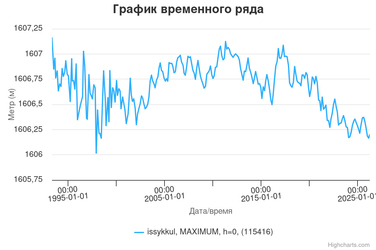
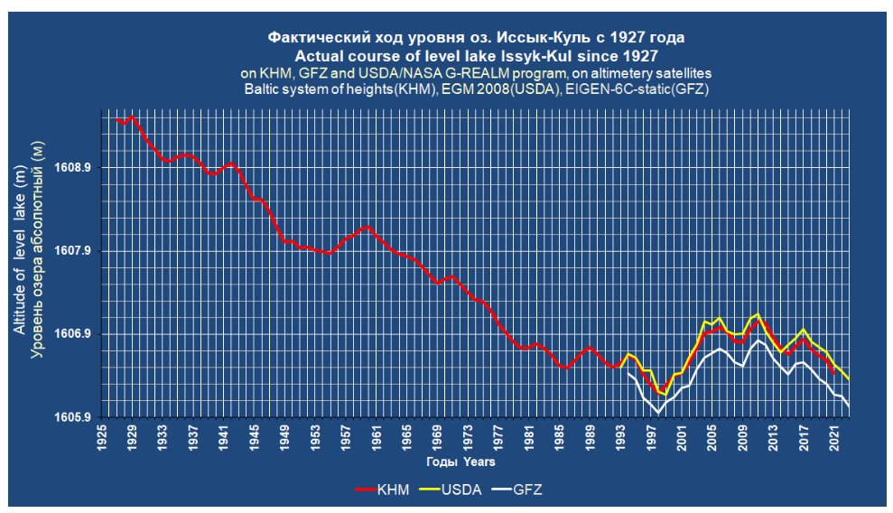
The current water level of Lake Issyk-Kul is the same as it was in 1998. The general downward trend since 1927 continues, but in certain periods it slows or accelerates.
This can be seen on the graph of the water level based on satellite data from GFZ (Deutsche GeoForschungs Zentrum) https://sdss.caiag.kg/sdss/index.php?&page=measure_page The graph with data from May 14, 1993 to March 30, 2026 shows that from 1998 to 2026, the water level rose (1) and then fell back to its initial position, meaning there was no overall decline.
Observations of Lake Issyk-Kul's water level since 1927 and modern methods can be found in the article "Monitoring the Long-Term Variation of Lake Issyk-Kul and Chatyr-Kul Based on Altimetry Instruments and Optical Satellite Images" (2) by a senior researcher at the Central Asian Institute for Applied Geosciences Alexander Nikolaevich Mandychev.
The main water level monitoring is carried out by the Hydrometeorological Service of the Ministry of Emergency Situations of the Kyrgyz Republic (Kyrgyzhydromet). Measurements are taken morning and evening at stations in Balykchy, Cholpon-Ata, and the villages of Koy-Sary and Tamga. The Central Asian Institute for Applied Geosciences continuously monitors the water level of Lake Issyk-Kul using satellite data. The Ministry of Natural Resources, Ecology, and Technical Supervision of the Kyrgyz Republic conducts comprehensive studies of the water area.
Fluctuations in the water level of Lake Issyk-Kul are characterized by short-term cycles of 3-4 years and long-term cycles of decades. A sharp decline is considered a change of more than 10-20 cm per year. Data may vary depending on the season and location of the measurement.
Rising temperatures reduce the area of glaciers that feed rivers and increase evaporation from the lake's surface. Reduced precipitation in winter and spring affects inflow. Also, due to increased irrigation of agricultural lands, the volume of water from rivers to the lake is decreasing. In the long term, a slow subsidence of the lake bed may lead to a decrease in water level.
If this trend continues, we can predict changes in water salinity, siltation of the coastal zone, degradation of flora and fauna, and an impact on the climate of the Issyk-Kul Basin.
To stabilize the lake level, the "Concept for Sustainable Development of the Issyk-Kul Ecological and Economic System through 2030" includes measures such as strict monitoring of irrigation water intake, modernization of irrigation systems, implementation of water-saving technologies, expansion of green areas around the lake, study of the condition of glaciers and water sources, and development of climate adaptation strategies.
To prevent a level decrease in other lakes in Kyrgyzstan, it is important to continuously monitor glacier conditions, prevent pollution and ecosystem degradation, implement automated systems for measuring water levels, and coordinate water use.
Links:
1. https://caiag.kg/images/2%20Department/2018/IK_river_Kalashn_2017_ru.pdf
2. https://caiag.kg/images/2_department/2023/Monitoring_level_of_lake_Issyk-Kul_RU.pdf
3. https://www.gov.kg/storage/media/npa/4743/692e8d7c9d25f.pdf