GIS "Narynvodokanal"

 The GIS Narynvodokanal system was developed within the framework of the project “Rehabilitation and expansion of water supply and sewer networks, as well as checking for the detection of water leaks” funded by the European Bank for Development and Reconstruction (EBRD) in the part “Development of a geographic information system (GIS) of the city of Naryn with support for Internet information portal ".
The system is designed to support effective planning and asset management of Narynvodokanal using databases, GIS and Internet technologies.
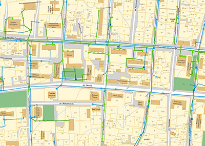
The system represents a water supply and sewerage network in the form of an interactive map that you can pan, enlarge / reduce, view attribute information about objects, edit both network elements and objects of topographic and cadastral layers, print individual fragments.
The following work was carried out: 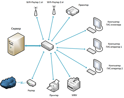
- An inventory of the assets of the water supply and sanitation network, GPS surveys of ground control points, drawing up diagrams and specifications of network components. These works were performed by the contractor’s specialists together with the specialists of Narynvodokanal.
- Shooting of the city of Naryn with specialized UAV Phantom-4 equipped with high-resolution photo-shooting equipment and, based on the survey results, an orthophotomap was synthesized which was used for high-precision geo-referencing of VSK objects, cadastral and topographic maps.
- Digitization of the topographic base and cadastral map is carried out, vector layers of water supply and sewage networks with attribute data are compiled.
- Cadastral sections were linked to subscribers of Narynvodokanal.
- Two versions of the GIS system have been developed: local, with advanced features - for corporate use by specialists of Narynvodokanal and the Web version for access to the simplified version of the public system.
- A series of training seminars on GPS surveys, UAV surveys and the use of a GIS system.
Office equipment was purchased and installed, and a local area network with WiFi support was deployed.